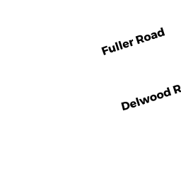
10 DELWOOD RD
Owner Information
PAPPERT JEFFREY M &
10 DELWOOD RD
CHELMSFORD, MA 01824


Property Details
10 DELWOOD RD is classified as a Single Family Residential (Colonial).
The primary structure on this property was built in 1940. There are 3,728ft2 of built area within this property. There is 1,940ft2 of residential/living space within this property.
10 DELWOOD RD is valued at $476,900. The land is valued at $232,800 and the structures are valued at $238,700. There is an additional valuation of $5,400 on this property.
This property is in Zone RB. Confirm with local Zoning Board authorities to ensure there are no overlays or other easements on this property.
The most recent deed for 10 DELWOOD RD is recorded at the local registrar in Book 26879, Page 0179. 10 DELWOOD RD was last sold on Wednesday, January 16, 2013 for $425,000.
Assessment data from fiscal year 2022.
Flood Data
According to the FEMA National Flood Hazard Layer, this property does not appear to be in a flood zone. It may also be in an area not yet reviewed. Nonetheless, confirm this information prior to taking any action.
To view the flood hazards around this property, create a FEMA "Firmette" Map of the area around 10 DELWOOD RD.
Broadband Internet Providers
| Provider | Type | Bandwidth (mbps) | |
|---|---|---|---|
| Comcast | Cable | 1000 | 35 |
| VSAT Systems, LLC. | Satellite | 2 | 1 |
| Viasat Inc | Satellite | 100 | 3 |
| Verizon New England Inc. | Fiber | 940 | 880 |
| GCI Communication Corp. | Satellite | 0 | 0 |
| HughesNet | Satellite | 25 | 3 |
Broadband service provider data from December 2020.
Adjacent Properties
- 7 FULLER RD
Single Family Residential owned by TAYEBI R0NALD - DELWOOD RD
Undevelopable Residential Land owned by PAPPERT JEFFREY M & - 12 DELWOOD RD
Single Family Residential owned by BUSHNELL DOROTHEA A TR - 8 DELWOOD RD
Single Family Residential owned by KING JEFFREY S & - 3 FULLER RD
Single Family Residential owned by TZIOLIS NICHOLAS A